



MOVE-ME.AMP

Descrizione di MOVE-ME.AMP
** MOVE-ME.AMP ONLY WORKS IN OPORTO CITY **
MOVE-ME.AMP is a prototype of an application that allows mobile access to global and diversified information about public transports available in Oporto city.
Fully new in Portugal, MOVE-ME.AMP shares to the final user wide and spread information concerning several operators of public transports and allows planning our routes in real time with features like intermodality and real time.
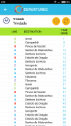
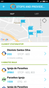
Nevertheless, the system allows finding the next departures, consulting the waiting times and destinations that are associated to next vehicles of a place chosen by the user.
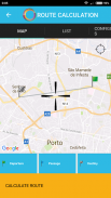
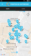
An integration of maps enables the user to define a localization providing information such as:
• What are the nearest stops?
• What are the nearest points of interest?
• When is the next vehicle to pass in this stop?
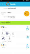
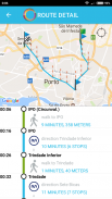
The route finder helps the user to find the best route to a specific place. The places can be bus stops, metro and train stations, points of interest and GPS localizations. The solutions given take into consideration the real time vehicle positions and return the best option for that moment. The system informs the passing time for each stop, the local place to change and walking route between them.
** Move-ME.AMP funziona solo in Oporto City **
Move-ME.AMP è un prototipo di un'applicazione che consente l'accesso mobile alle informazioni globale e diversificata su mezzi pubblici disponibili nella città di Oporto.
Completamente nuovo in Portogallo, Move-ME.AMP azioni per l'utente finale di larghezza e diffondere informazioni riguardanti diversi operatori di trasporti pubblici e consente di programmare le nostre vie in tempo reale con le caratteristiche come l'intermodalità e in tempo reale.
Tuttavia, il sistema permette di trovare le partenze successive, consultando i tempi di attesa e le destinazioni che sono associati alle prossime veicoli di un luogo scelto dall'utente.
Un'integrazione di mappe consente all'utente di definire una localizzazione che fornisce informazioni quali:
• Quali sono le fermate più vicine?
• Quali sono i punti di interesse più vicini?
• Quando è il prossimo veicolo a passare in questa fermata?
Il cercatore di percorso aiuta l'utente a individuare il miglior percorso per un luogo specifico. I posti possono essere fermate degli autobus, stazioni della metropolitana e dei treni, punti di interesse e GPS localizzazioni. Le soluzioni date prendono in considerazione le posizioni del veicolo in tempo reale e restituire l'opzione migliore per quel momento. Il sistema informa il tempo che passa per ogni fermata, il posto locale di cambiare e percorso a piedi tra di loro.


